Boat Charter Croatia: Nautical Pilot for Adriatic (Kroatien) with Maps and Images
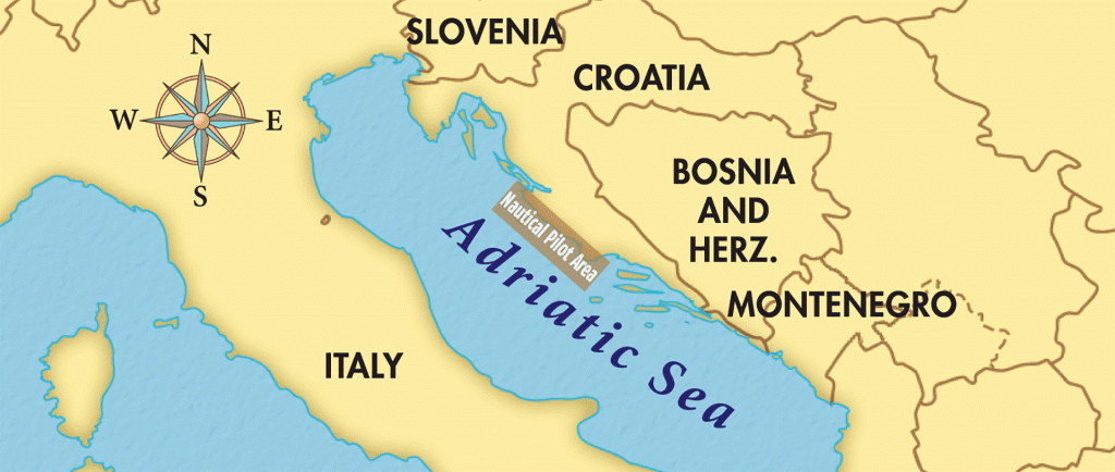
West Adriatic sea pilot, sailing maps and advice for your bareboat Croatia (Kroatien) charter vacations
If you don’t use skippered yacht charter and you go with a bareboat charter in Croatia Adriatic Sea pilot like that is really helpful. This pilot is perfect for persons who want to skipper their own yacht.
We are cover here West Adriatic Sea area. You have quality navigational advice shared in categories as Facilities, Connections, Nearby Anchorages, Moorings, etc.
Croatia is a great place for the sailing holidays and yacht charters. There are hundreds of small coves ideal for anchoring and sail charter in Croatia.
More than 1200 Adriatic Sea islands on the coast side of Croatia, pretty simple jump out as one of the best sailing locations of all in Europe.
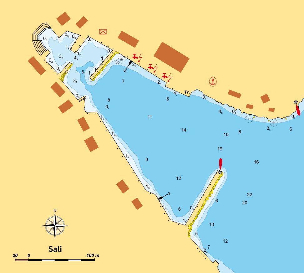
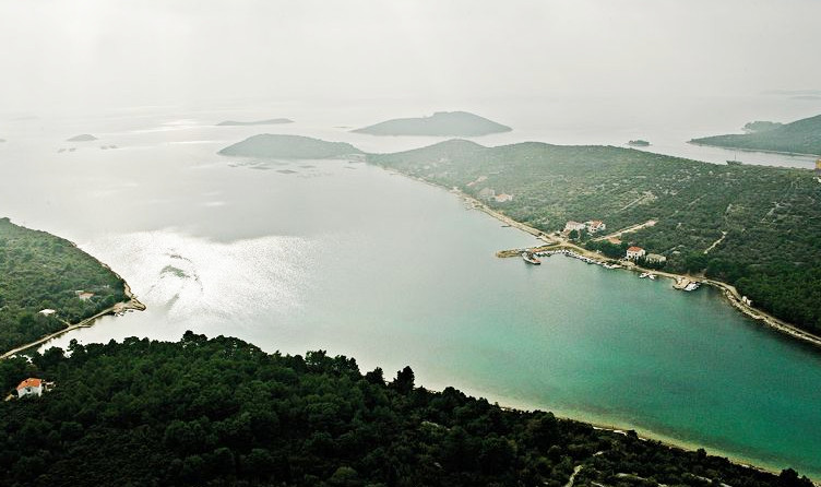
SALI
43°56.1’N, 15°10.4’E – lighthouse at breakwater headThe spot might be temporarily vacant, it is still reserved for them. You can secure alongside the coast of the peninsula (with Bluda Point), between the ferry quay and the inner breakwater root. Depths are from 5 m at ferry quay to 2 m at breakwater root. Berths are provided with water and electricity. At the head of the inner breakwater the depth is 4 m, but when entering the inner aquatorium of harbor, watch out for the submarine reef nearby the breakwater head. On the inner side of the breakwater the depth is 4.5 m, up to the point where the breakwater meets the coast. Here the depth is 1 m. Usually there is no vacancy alongside this breakwater. The end of the cove is enclosed by two more breakwaters (facing each other), but these are quays with local boats. Alongside the opposite coast of the bay there is a concrete waterfront with restaurant terraces. The coastline depth is about 1.5 m. You can tie up stern-to-shore with bow-to shore.Weather Conditions
Sali Harbor is protected from all winds, except SE winds which raise swell.
Facilities
Water and electricity on berths
Seasonal border crossing
Harbor Authority
Police, Customs office
Outpatient’s center, dentist
Post office
Grocery shop
Open-air market and fishmonger’s shop
Connections
Daily liner to Zadar
Road connections with the rest of island
Nearby Anchorages
Veli Bok Cove on the island of Lavdari. Anchorage is well protected from the S wind, 1.5 miles away to NE off Luka Sali. A cove with afforested shores, just at the foot of the highest peak of Lavdara (88 m). Anchorage at depths of 10–15 m. The bottom is sandy. Rašovac Cove on Dugi Otok, 1.8 miles alongside Dugi Otok to SW. The cove is protected from all winds, except N and NE winds. At the end of the cove there is a small quay with the depth of 1 m. In close vicinity of a deserted house there is a boat winch. Anchorage at depth between 5 and 8 m. The bottom is sandy.

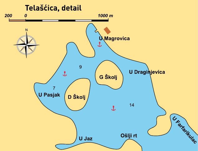
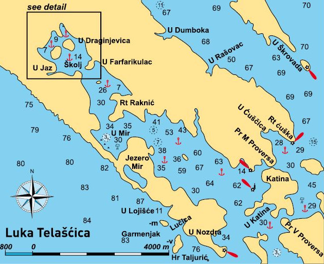
LUKA TELAŠĆICA
43°53’N, 15°12.9’E – lighthouse on Školjić Reef
Entrance
Entrance to Telašćica Cove cannot be unambiguously determined. One look at the chart tells you that the simplest way to define the cove entrance is as the sea enclosed by Dugi otok and the island of Katina. This encompasses two cove entrances, the one through Mala Proversa and the one from direction of Sestrice lighthouse. Entrance from Sestrice direction is 2 cables wide, 50-odd m deep, and without shoals alongside the shore. En-trance from Mala Proversa direction is much narrower and shallower, but well regulated by maritime signalling system (buoys and lighthouses). The entire channel depth does not drop below 4 m. South pair of buoys is considered entrance, so leave red buoys to starboard when going to Telašćica Cove (from Ćuška Point direction).
Moorings
The only available berths for yachtsmen are occupied by tourist boats in Mir Cove. There is a restaurant in close vicinity of the above-mentioned quay. Alongside the restaurant the shore is shallow and you can reach it by bay-boats. Telašćica Cove is known as safe anchorage. Telašćica can be divided into three parts: outer, enclosing Raknjić Point from the inside, with best anchorage Ćuška Duboka Cove deeply receding into the mainland. This outer part of Telašćica is exposed to the strong S wind. Ćuška Duboka shores are barren and steep. In deepest part of the cove you can anchor at the depth of 3 m. Mir Cove , with tourist boat quay in its southernmost part can be recognized by a big metal buoy anchored in the middle of the cove. Around the buoy there are many smaller buoys for yachtsmen. The middle part of the cove stretches from Raknjić Point to Ošlji Point, which together with the opposite point completely encloses and protects the deepest part of the cove from all winds. In the middle part, at well known anchorage – Kruševica Cove, in summer you can feel wind impact in the strong sea breeze.
Weather Conditions
Since the cove is very deep, and also wide at the front, you can anchor relative to weather conditions. E side of the outer cove is protected from the bora, but not from the S wind. Mir Cove is a perfect refuge from the S wind. The S wind does not affect the third, most closed part of the cove. Summer squalls, which occur here at the time of Feast of the Assumption, can confuse yachtsmen since there are a large number of those who anchor in this cove tying up their lines to the shore, i.e. trees. In stronger squall gusts, being unable to turn bow to wind, they be-come prisoners of faulty anchoring.
Facilities
Several restaurants
Connections
There is no regular liner connecting Telašćica to the mainland, but daily several tourist boats come to Mir Cove so it can be considered one of most mainland-connected island places. Besides, the deepest part of Telašćica Cove is connected to Sali by road. The road reaches the sea in Magrovica Cove. Alongside small quays in this cove the depth is 1 m. In the middle of the cove it is 3 m.
Nearby Anchorages
Šipnate – 2 nm SE of Katina there is Šipnate Cove (island of Kornat). In front there is the island of Šilo, and between an-other three small islands. You can anchor at depths of 3–5 m, the bottom is sandy. The cove is protected from all winds, but in the case of a stronger sea breeze, use one of the three small islands as a refuge.
General
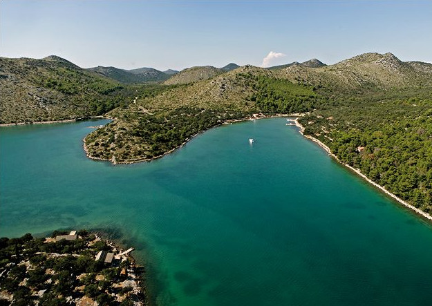
Telašćica Nature Park is a spacious cove in far south of Dugi otok, about 5 nm long. On E coast there are Ćuška, Dumboka, Ošćenica, Gozdenjak, Rakvić, Kraševica and Mangrovica Coves, and in W Strižna, Tripuljak, Mir, Jaz and Pasjak Coves. In western extension there are the islets of Donji Školj and Gornji Školj, in the middle the islet of Farfarikulac, and in the E – stretching to islands of Velika Aba and Katina – Gozdenjak and Galijola Reefs and the islet of Korotan. NE coast of Telašćica is mostly barren, and in SW under pine forest, olive and fig trees; a little bit further away from the coast macchia and forest at places. A narrow afforested ridge divides the S coast of Telašćica from the open sea, ending in 50–100 m high and steep shore. There is a salt lake (bathing zone) in this area; area of 0.23 km 2 , depth 5.8 m.
Points of Interest
Telašćica is a nature park and accordingly, a protected zone of natural and cultural heritage of the Republic of Croatia. The salt lake is considered curative, which attracts many people to Telašćica. Steep slopes at west end of the island are especially appealing.
Approach
If approaching Telašćica from Kornati archipelago, or along W side of Dugi Otok, excellent landmark is a tall tower of Sestrice lighthouse. The lighthouse is situated 1 nm S of the widest fairway leading to Luka Telašćica. This lighthouse tower is en-circled by a distinctive red-coloured stripe. From the lighthouse on Vidilica Point free course to Škojić lighthouse E3133. En-trance to the cove is W off Školjić light-house. If approaching Telašćica Cove from Kornati archipelago, leave the approach lighthouses to port, except the lighthouse on Školjić Reef. Round it from W (leave the lighthouse to starboard). NE off the island of Školjić there is another shoal mark. In Telašćica Cove no lighthouses. If approaching Telašćica Cove from sea area E off Dugi otok, after rounding Ćuška Point (and its lighthouse), lateral marks will break open in Mala Proversa fairway. After passing through Proversa, entrance to Telašćica Cove is just behind the red lighthouse (E3132.8) on Proversa Point.
Anchorage in the Approach
Since Telašćica is the biggest cove in the Adriatic, about 5 nm deep, you can anchor almost anywhere alongside the coast this cove is made of. Relative to wind direction and strength, choose E or W coast of the cove.

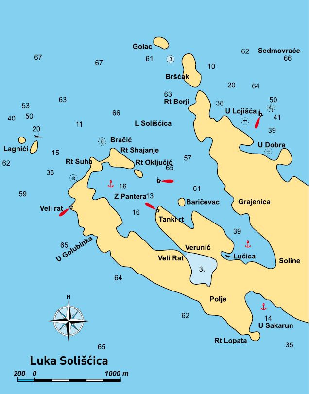
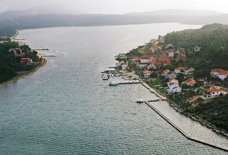
LUKA SOLIŠĆICA
44°11.4′ N, 14°51′ E – lighthouse on island of Golac, at N end of Dugi otok
General
Luka Solišćica, a deep cove, favorite anchorage for yachtsmen. It is made of three smaller coves interrelated by narrow fair-ways. There are four settlements on their shores: Soline, Veli Rat, Verunić and Polje. Soline area was named after former salt works. People lived here in Roman times. Pantera Cove is also known as a place where you can find very big samples of pen shell. Bear in mind that they are protected and that it is illegal to dive them out.
Points of Interest
In Soline Church of St. Jacob from the 15 th century (renovated in the 19 th century). In Veli Rat Church of St. Anthony from the 14 th century. In Verunić Church of Our Lady of Mount Carmel built in 1679. Inside Veli rat lighthouse also weather station.
Approach
The name Sedmovraće (Seven Gates) indicates that when approaching Luka Solišćica, you pass between (or by) seven gates made of the islands in close vicinity. Veli Rat lighthouse is discernible from the distance of 22 nm (at night), and its 36 m tall white tower is also a good landmark in daylight. Luka Solišćica is in fact made of two deep coves divided by the peninsula with the settlement called Verunić. At the end of E arm of cove there is a settlement called Soline. In W arm of Luka Solišćica there are settlements called Veli Rat and Polje. You can avoid all Sedmovraće gates if you enter Luka from NW. A wide entrance to the cove breaks open between the island of Golac (with lighthouse) and Shajanje Point. When approaching from that direction, watch out for shoals round the island of Lagnići, indicated by a clearly discernible stranded ship NE off these islands. Watch out for the same shoals when entering from S. After rounding the point with Veli rat lighthouse, the course takes you between the already-mentioned Lagnić and Suha Point. After rounding Shajanje Point, you will find yourself in Luka Solišćica. If you approach Luka from Sedmovraće direction, a wide entrance to Luka Solišćica will break open immediately after rounding the island of Golac with lighthouse E3094.4. You can enter Luka between the islands of Golac and Bršćak. Between them 3 m deep shoal.
Anchorage in the Approach
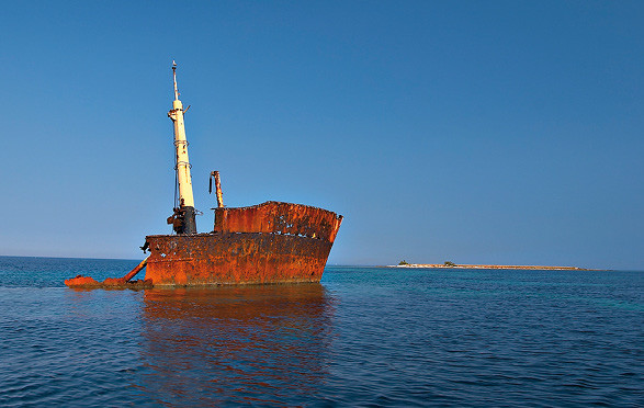
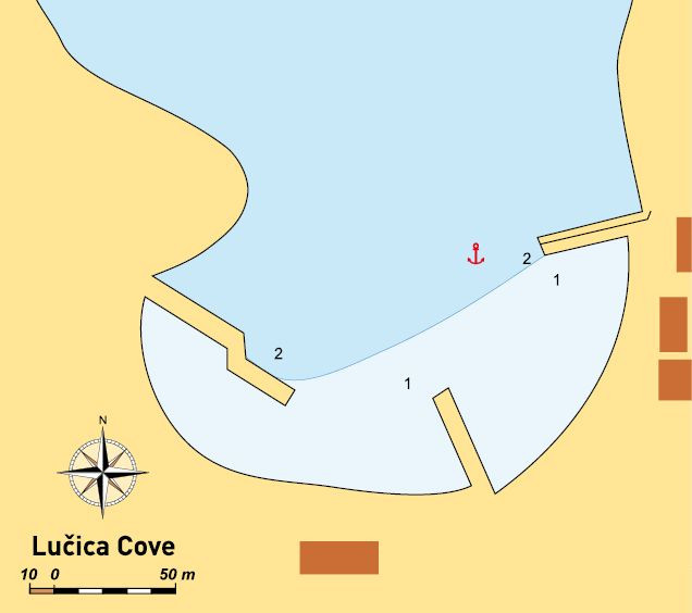
If you want to secure in Soline Harbour, you can stay at anchor W off breakwater of Soline Harbour; most protected cove is NE off breakwater, Lučica cove. Lučica shores are afforested, and ashore a lot of small quays were built. There is a sunken ship in the cove whose remains jut out of the sea. The bottom is sandy. Anchorage is at depths of 4–7 m. If you want to secure in Veli rat Harbour or anchor in the cove of a deeply receding settlement of Polje, you can anchor in approach in spacious Pantera Cove. Inside the cove many anchored buoys for yachtsmen. Anchorage is at depths of 3–7 m. The bottom is sandy.
Entrance
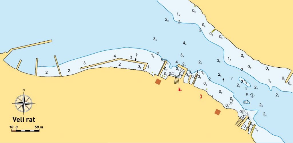
Entrance to Luka Solišćica is at the same time a beginning of a long cove stretching to SE, with the settlement of Soline at its end. Local boats are protected from NW winds by a small breakwater connected to the E coast of the cove. Quay entrance from the inner breakwater is wide, but watch out for the depth. At the breakwater head it is 2 m. On W coast of the cove another break-water enclosing the haven brimming with local boats. From the shore to the L-joint, from the outer side rocks jutting out from the sea. Alongside the head the depth is 2 m, and the inner breakwater depth is 2.5 m. Only at the end of the inner breakwater the depth drops to below 1 m. At the end of the harbor a boat winch. Entrance to Veli Rat harbor (and further on to Čuna Cove S off Veli Rat) between the lateral mark on a buoy SE off Oključić Point and the lighthouse on Tanki Rt (point). When entering, watch out for the islet of Baričevac. It is situated 4 cables SE off the mentioned buoy. Entrance to Veli Rat harbor is made of the first and the second breakwater. The first one is flat, and the second L-shaped. At the head of the first breakwater the depth is 2 m, and at the head of second 3 m. There is a fairway leading to Čuna Cove marked by two marks on either side of the fairway. The f airway depth is 2.5 m.
Moorings
Inner breakwater alongside E coast of Soline Cove, the depth is 3 m at the head, gradually dropping to 1.5 m somewhere in the middle of the breakwater. Towards the shore it gets shallower. In Veli Rat harbor you can moor to the outer side of the L-shaped breakwater where the depth is from 3 m at the head, to 2 m closer to entrance to Čuna Cove. The same depth at the break-water head and alongside its inner part. From the breakwater joint the depth drops to 0.5 m at the end of the harbor. The boat winch is on inner L-shaped breakwater. To W there is a long pontoon (c. 120) mostly used for summer boat mooring and much safer. On several other quays on either side of the channel between Veli Rat and the opposite settlement (Verunić) on Tanki Rat peninsula, depths are about 1 m. In Čuna Cove several restaurants built their own quays with depths between 1.5 and 2 m. It is deepest alongside the first quay (Dim restaurant), and at the head of this quay there is also available electricity cabinet (but make previous arrangements with the restaurant). In Čuna Cove 8 available buoys.
Weather Conditions
Luka Solišćica is protected from all winds, except NW, which it is completely ex-posed to. Pantera Cove is completely protected from all winds, except the strong bora which raises swell at anchorage. Čuna Cove is well protected from all winds.
Facilities
Pipeline water (Veli rat, Soline)
Post office (Veli rat)
Grocery shop (Veli rat, Soline)
Outpatient’s centre (Soline)
Restaurants (Verunić)
Connections
Connection to the mainland through Božava harbor
Nearby Anchorages
Sakarun Cove – A cove on W coast of Dugi Otok. It is 6 nm away, and you need to round Shajanje and Veli Rat points. The bottom is sandy, and you can anchor alongside the en-tire cove’s width at depths of 4–10 m. The cove is protected from all winds, except the S wind, which can be very dangerous. Sakarun Cove is one of the rare coves on the W coast of Dugi Otok.
Dobra Cove – A cove on E coast of Dugi otok. 5 nm away from Soline. You can reach it between the island of Golac (with light-house) and island of Brščak. There is a shoal of 3 m between them. Between Lojišće and Dobra Coves several reefs and shoals marked by lighthouse (E3099.5). Watch out for submarine reef 2 cables NW off the lighthouse. Dobra Cove is a good refuge from the S wind, but usually not good anchorage in the case of N and NE winds. At the far end of the cove boats are safe from the bora, too. The bottom is sandy, and anchorage at depths of 5–10 m. In the middle of the S coast there is a submarine reef.
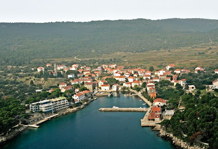
BOŽAVA
44°08.5’N, 14°54.9’E – Sveta Nedjelja Point
General
Božava is situated on the NE coast of Dugi otok, in the S of Zverinac Channel. The place where it is situated is called Božavsko Polje. Božava has a big breakwater, raised and built in 1920s. In Illyrians times, in Božava’s vicinity there were two fortresses. Besides these wall remains there are also remains of Roman buildings. Božava is first time mentioned in written records
in 1327 under the name of Bosana. According to some findings in Špinat area, it is presumed that the Slavs founded their settlement here in the 9th century. Parish church is presumed to date back to the 9th century, as well as Church of St. Nicholas at the cemetery.
Points of Interest
Nearby some houses alongside the coast-line you can see yards enclosed by stone walls with loopholes for defense against the pirates in the 18th century.
Approach
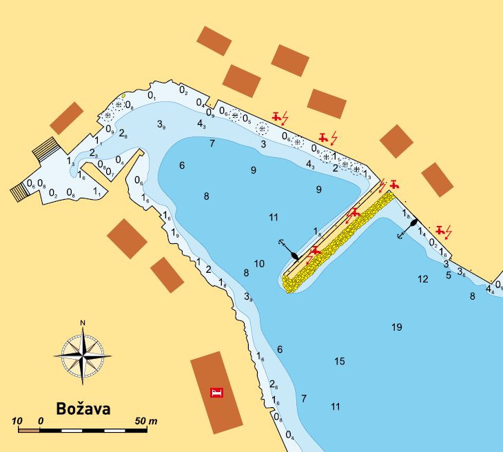
As landmarks you can use the church belfry in the settlement (although the hotel building in church vicinity is much more conspicuous), the chapel and the lighthouse on Sveta Nedjelja Point. If you approach the harbor from NW, watch out for reefs and shoals between N end of island of the Zverinac and Lojišće Cove on Dugi Otok. They are marked by light-house E3099.5. If you approach from S, the available course is from the light beacon on Beli Shoal (8 cables NW of the island of Beli) towards Sveta Nedjelja lighthouse. In daylight pilot alongside Dugi Otok, watching out for the shoal between the islands of Planatak Veli and Planatak Mali. The harbor is divided by a breakwater connected to the E coast of bay. In the case of a strong S wind it is not recommended to enter Božava Harbour.
Anchorage in the Approach
It is uncommon to anchor in harbor vicinity owing to heavy traffic. Besides liners, tourist boats very often secure there. Four cables to south alongside the coast of Dugi Otok two sandy coves which can serve as an anchorage during day.
Moorings
The sea depth from the breakwater to the place where the liner secures (to S) is very uneven, so mooring difference could be above 1 m. There is no rule, so watch out for the depth at the place where you secure. At breakwater and shore intersection rocks reduce depth to below 1 m. Then it mildly drops to 3 m, but you can run into big rocks. In front of the protruding section indicating the beginning of the liner quay, depth is only 1.5 m. Then it suddenly drops again alongside liner quay. You can also anchor to inner breakwater. From the head to the shore the depth is from 3 m at the front, then 2 m in the middle of the inner break-water, and then again rising to 3 m before it begins to descend to 1 m inshore. The i n-shore depth is also unusual. Namely, along-side the shore there is a plateau at the bot-tom stretching 3–4 m into the sea, where it is shallower, and then towards the middle of the cove the depth suddenly drops. On this plateau in the first part of the harbor it is about 1.5 m, somewhere also 2 m, and from the mild joint towards the end of the cove it drops to 0.5 m. Here also you need to be very careful as there is no gradual rise or drop in depth. Smaller dock at the end of harbor (with a tall concrete wall above) is brimming with local boats. All berths are provided with water and electricity. Moorings at quays.
Weather Conditions
The cove is protected from all winds, except the S wind. In the section of the harbor protected by a big breakwater the S wind raises uncomfortable swell. Also be careful when the forecast announces summer squalls as they bring very strong wind into the cove.
Nearby Anchorages
Dumboka Cove, 2 nm southwards, an excellent refuge from the S wind, but not from the bora. The landmark is island of Magarčić at the cove entrance. The bottom is sandy, and anchorage at the depth of 5 m. The cove has two arms, in one of them a clearly discernible military pillbox. You can moor alongside the concrete coast in W of the bay. Dobra Cove, 2.5 nm N of Sveta Nedjelja Point. A good refuge from the S wind, but not from the bora. The cove entrance is behind Zaglavić Point. In the middle of Dobra Cove, closer to the south coast, watch out for the reef. The bottom is sandy. Anchorage is at depths of 3–7 m. Kablin Cove , 1.5 nm NE on the island of Zverinac. A good refuge from the bora, the bottom is sandy and anchorage at depths of 8–10 m.
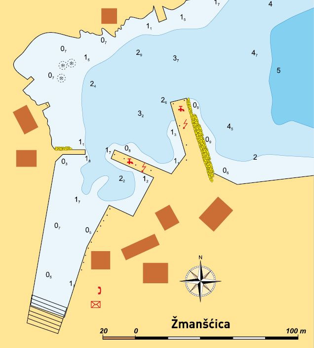
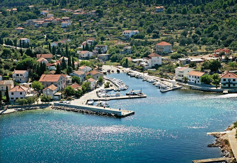
ŽMANŠĆICA
43°58.4’N, 15°07.4’E – lighthouse on N coast of Žmanšćica Cove
General
Žman is first time mentioned in the 13th century under the name of Mežano. Parish Church of St. John was also built at the same time. Moreover, findings from the prehistoric age (stone axe), inscribed tombstones, etc. bear witness to a much earlier presence of people on Dugi Otok. Since times immemorial the inhabitants of Žman have been ploughing two arable fields, Velo Jezero and Malo Jezero, which are very rich with water when it comes to island conditions. The settlement is situated alongside the coastline of Žmanšćica Cove, but also on nearby hillsides.
Anchorage in the Approach
You can anchor alongside entire the coast of the island of Krknata, which provides you with an excellent refuge from all winds. The bottom is muddy, and you can anchor at depths of 3–7 m. In SW of the island the bottom is partially rocky. In the case of fair weather you can anchor in close vicinity of entrance to Žmanšćica Harbour. The bottom is sandy, and anchorage at depth of 4–6 m.
Entrance
Entrance to harbor is alongside the break-water head. The entrance depth is 4 m. On opposite, N coast of the cove there are a lot of reefs, so pilot closer to the breakwater head. If you are heading for the inner harbor with en-trance between two smaller breakwaters, come in through 7 m wide entrance, depth 1.5 m.
Moorings
You can secure alongside the inner bigger breakwater with a lot of raised rocks on the outer side. The breakwater head depth is 4 m, and midway of breakwater it drops to 2 m. At the intersection between the breakwater and the coast, and alongside the coast until the beginning of a smaller (inner) breakwater, the depth is 1 m. Alongside this breakwater, towards the one on the opposite side of the cove, the depth is 0.5 m. It remains the same to the head, where depth is 1.5 m. In the inner fishing harbor depths are 1–0.5 m. At the head of big breakwater there is a small cabinet with water and electricity. At the end of cove there is a boat winch.
Weather Conditions
The outer side of Žmanšćica Cove is not a good refuge in bora. Only in the section shielded by two small breakwaters, but occupied by local boats, there is a safe refuge from the bora. In all other winds the harbor is well protected.
Nearby Anchorages
Luka Cove : 1.5 nm NW of Žman Point. Enter Luka Cove between Gubac Point on Dugi Otok and the S end of the island of Luški. The depth in this fairway is 2.5 m. In southernmost part of the cove there is a settlement of Luka. Berths on the dock near-by a neglected house, the building of former Harbour Authority. The depth at N end of the waterfront is 3 m, then it drops to 1 m nearby the neglected house, and at the end of the waterfront stretching towards the end of the cove, it is 1.5 m. Berths are provided with moorings. Yachtsmen have a cabinet available with water and electricity. On the E coast of the cove a hotel with a spacious concrete and stone beach, used exclusively by hotel guests. Anchorage at depths of 4–10 m. The bottom is sandy. Luka anchorage is protected from all winds except the strong Tramontana.
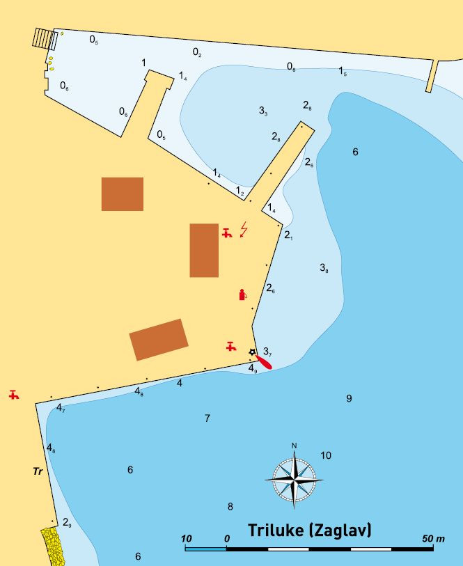
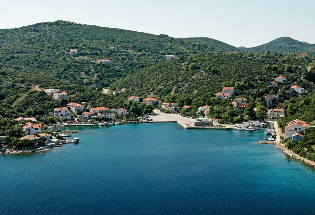
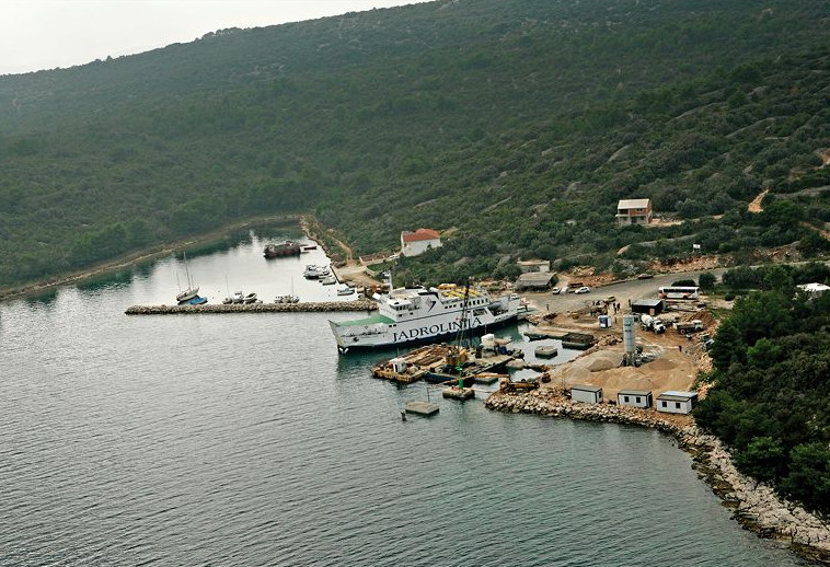
TRILUKE (ZAGLAV)
43°57’N, 15°09’E – lighthouse on ferry quay
General
Zaglav is situated on the plateau above Triluke Cove. Nowadays increasing new building constructions by the sea in Zaglav. Zaglav has recently become an important transport and transit center, primarily owing to the well protected quay and fuel station. Otherwise, the settlement is mentioned in the 15th century; Franciscan monastery and Church of St. Michael also date from the same time. In church epitaph from 1559, stone engraving in the Glagolitic script.
Anchorage in the Approach
The aquatorium shielded by long breakwater is deeper in the N. The sea is shallowest in the S of the cove, where the breakwater meets the shore. In the vicinity a huge quarry, made after soil excavations for breakwater construction. You can anchor alongside the shore which is in line with the quarry, to the end of the cove in the SW of the harbor aquatorium.
Entrance
Entrance is wide, with deep sea, and is made of the lighthouse at the end of the breakwater and the easternmost point of the peninsula ashore, towered by the largest part of the settlement of Zaglav.
Moorings
For shorter stays there are berths alongside the fuel station, and for long-er stays (until having obtained all sup-plies) you can stay in N of the water-front. Alongside the entire waterfront with fuel station the depth is 3 m. In the inner waterfront (N) there is a quay with local boats tied up. On the other side of the fuel station (S side) there is a ferry quay. A lot of vessels come to Zaglav for fuel, so in season it is customary to obtain fuel and leave.
Nearby Anchorages
Žmanšćica Cove is NW off Triluke. The inner haven is a good refuge under all conditions, and at anchorage boats are exposed to the bora. Depths along-side the outer breakwater are 1–2.6 m, with water and electricity points. The Island of Krknata aquatorium, 1 nm N alongside Dugi Otok coast. You can anchor alongside the entire coast of the island of Krknata, which provides a good refuge in all winds. The bottom is muddy, and you can anchor at depths of 3–7 m. In SW part of the island the bottom is partially rocky.
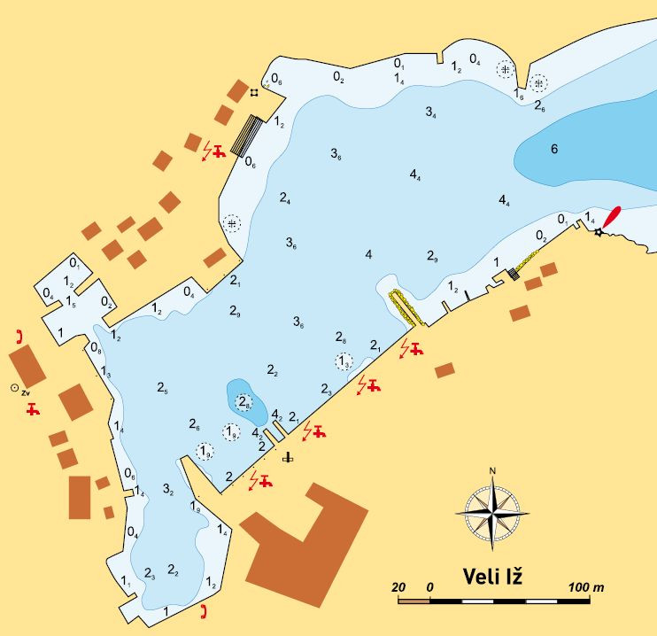
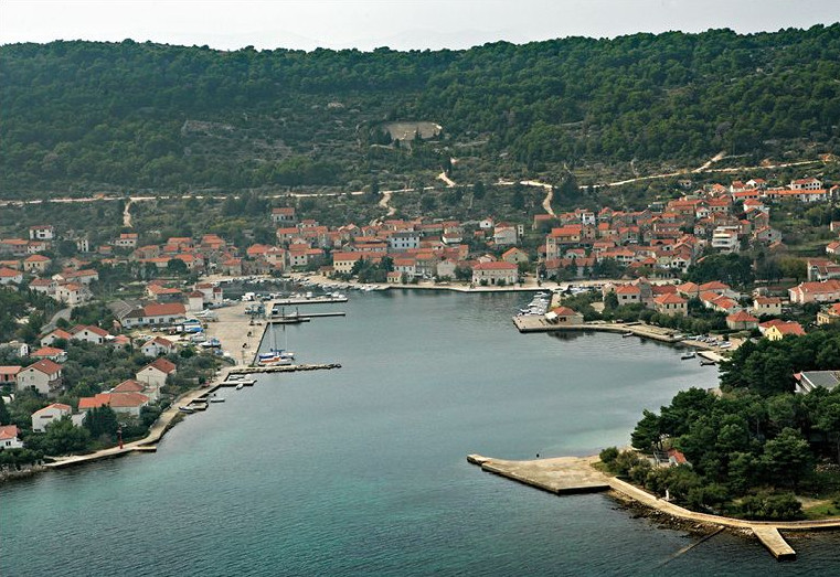
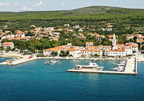
VELI IŽ
44°03.1’N, 15°07’E – lighthouse at harbor entrance
General
Veli Iž is a settlement that has managed to preserve the old town core, and display its customs and traditional island lifestyle at the Ethnographic Museum. Museum is abounds in pottery exhibits from Iž, and tool collections of traditional pottery craft. Besides the traditional products, the Modern Age products can definitely be seen in the services of the present day hotel in Iž and marinas built for yachtsmen.
Anchorage in the Approach
Maslinčica Cove – half a mile N off Veli Iž. At the end of the cove there is a small harbor of the settlement of Drage. The harbor is protected by breakwater, with 4 m depth (at the head), and 2 m depth inside. You can anchor between entrance to Veli Iž Harbour and this small harbor. The anchorage is at the depth of 4–8 m. The bottom is sandy. The anchorage is not protected from the south wind and the bora. Island of Rutnjak – you can anchor in its close vicinity, relative to wind. You can anchor at depths of 4–8 m.
Entrance
Entrance to Veli Iž Harbour is wide, and made of a red lighthouse at the S end, and, on the opposite coast, of an elongated low point of afforested peninsula, with a hotel building. Midway of entrance the depth is about 4 m, and remains the same until the first stone seawall which protects the cove from the bora. In the middle of the bay, in line with the marina, the depth is about 3 m. You can anchor to some of the marina berths, or on the opposite coast, alongside the concrete quay reserved for the liner. Boats with drought below 1.6 m can also moor alongside the concrete coast at the end of cove, but bow to the mainland.
Moorings
Berth depth in the entire marina is between 2 and 2.5 m. Just behind the stone seawall at en-trance, the depth is 2 m, and in the middle about 2.5 m, and at the end of the marina, at the concrete section indicating the end of the marina, the depth is 2 m. On the pontoon in line with this end in the inner marina aquatorium, and situated alongside the boat slipway, the depth at the head is 3 m. Berths are provided with water and electricity. Besides the reception, the marina also has toilets and showers, shop, 50 t boat slip-way, 200 sea and 50 land berths. It is possible to obtain engine, plastic, and particularly wood repairs in the marina, as marina is part of the former shipyard. Boats below 18 m can secure in the marina (relative to their drought). At the concrete quay for the liner (opposite the marina) depth is 2.5 m. At the deepest end of the cove, in its N and S, there are harbors for local boats. The N basin is shallower, 1–1.5 m, and the S basin, which is also more spacious (in the extension of the marina), has 2 m depth at entrance, while only 1 m alongside the coast. The ferry quay is without any moorings for yachtsmen, it is reserved for the ferry only.
Nearby Anchorages
Soline , the cove on the W coast of Iž. To Soline pilot around the northernmost point of Osiljinac, and then alongside the coastline to the island of Glurović. Between this island and Iž coastline there is a reef. Nearby the is-land of Glurović and the mentioned reef, to S, beginning of Soline Cove. The coast is afforested, and anchorage is at the depth of 5–8 m. The bottom is sandy. If entering the cove from SE, watch out for the shoal of 2 m 2 cables west off the point on the peninsula that encloses Soline Cove in W. There are several small piers in the cove, the depth at the head of the biggest (concrete) pier is about 2 m. When entering the cove, watch out for fish farm cages. The cove is not protected from winds from the fourth quadrant. N and S off the islet of Knežak, you can anchor relative to the wind. Depths are 5–10 m, bottom is good holding.
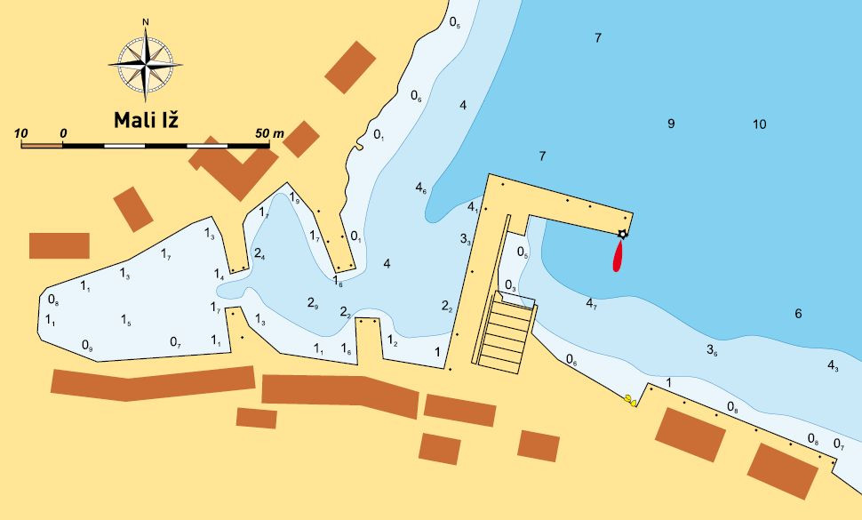
MALI IŽ
44°01.7’N, 15°08.7’E – lighthouse at breakwater head in Komoševa Cove
General
Three settlements merged into one to make Mali Iž. On three hills you will find Mućel, Makovac and Porovac. At their foot, alongside the coastline, the inhabit-ants of the mentioned settlements once used two coves: Knež and Komoševa. Both havens were characterized by fishing tool sheds. Mali Iž has preserved the traditional pottery craft. White clay pit in vicinity of Mali Iž. Gajeta falkuša (wooden sailing boat) from Komiža, representing Croatia at World EXPO in Lisbon, was stocked with clay dishes made in Mali Iž pottery style. All three settlements are towered by two unusually symmetric church-es, standing next to each other. For several centuries Mali Iž was an important Glagolitic center, mostly owing to the writer and the translator Šimun Budinić (1530-1600), who spent a larger portion of his life on Mali Iž.
Points of Interest
Clay dishes were not sold, but used in barter trade. The price was determined by the amount of grain that would fit into a bowl. Today you can easily recognize typical Mali Iž pottery.
Anchorage in the Approach
In front of each of the three described havens the bottom is sandy, and anchorage is at depths of 3–7 m. Favourite anchorages are between the island of Knežak and the mainland, and the nearby ferry quay in Bršanj Cove. Anchorages are not good refuges in the bora.
Entrance
Entrance to the fishing harbour in Komoševa Cove is made of stone the breakwater head with a red lighthouse and the opposite shore. At the intersection between the breakwater and the coast, on the outer breakwater, there is a boat winch. Closer to the breakwater head the depth is about 5 m, and in the middle be-tween the end of the breakwater and the coast – 4 m. When you enter the harbour, behind the breakwater head, pilot in line with the breakwater because on the opposite (smaller) breakwater the depth is only 0.5 m. Inside the harbour there is another entrance leading deeper into the harbour. It is made of two small-er breakwaters, and the depth between them is 2.5 m. It is entrance to the harbour section occupied by local fish-ing boats. Entrance to Knež Cove is made of two break-waters facing each other and the depth between them is about 4 m. At S breakwater head depth is 3.5 m, and on the opposite 2.5 m. Midway of en-trance the depth is 3.5 m. Entrance to Bršanj Cove and the ferry quay is wide and deep. The ferry quay keeps to the N coast of the bay and occupies almost the half of the cove.
Moorings
At the breakwater of the main fishing harbour in Komoševa Cove you can moor to the inner side of the outer breakwater. From 5 m at its head the depth drops to 4 m somewhere in the middle, and at the point where the break-water meets the coast it drops to 1.5 m. In the first inner basin behind the two smaller break-waters the depth is 1.5 m everywhere. In Knež Cove the depth at the outer S breakwater is 4 m at the head, and then drops to 1 m at the point where the breakwater meets the coast. Inshore depth is about 1 m, all the way to the winch. At the head of the inner breakwater, in the extension of the winch, the depth is 2 m. The two breakwaters facing each other are shallower. At the outer break-water the depth is 2 m at the head, and 1 m alongside the coastline. At the other, inner breakwater the depth is 1.5 m alongside its entire length.
Weather Conditions
Mali Iž Coves are protected from all winds, except the NE wind.

UGLJAN
44°07.8’N, 15°06.7’E – lighthouse at breakwater head
General
A haven and a settlement in NE of the island with the same name.
Anchorage in the Approach
You can anchor NE off the breakwater, but watch out for the depth as the entire area around harbour entrance is extremely shallow. The bottom is sandy and partially rocky. At depths above 10 m it is mostly muddy. You can anchor only when there is no wind, as it is exposed to all winds, except the W.
Entrance
L-shaped breakwater with a red lighthouse at the head stretches from the coast to N.
Entrance to the harbour is on its W side. The coast makes the other end of entrance. Inshore is shallow, so keep close to the breakwater head with the depth of 4 m. All the way to the break-water joint the depth drops to 3 m, and also in the middle of the harbour. In the middle of the narrow part towards the end of the harbour made by a broadened part of the main breakwater and opposite the breakwater the depth is 1.5 m.
Moorings
You can moor to the inner side of the break-water. At the head the depth is 4 m, at the mild joint 3 m, and at the point where the breakwater broadens up the depth is 1 m. At the head of the smaller breakwater that constitutes the inside of the haven (on the same side where the big breakwater is situated) the depth is 1.5 m. The inner harbour ends in a seawall which separates the harbour from the marshy lands behind the seawall. The depth alongside the seawall drops to 0.5 m at places, and grows to 1 m at other places, but without any conspicuous pattern.
Nearby Anchorages
Čeprljanda Cove – only one point to S off the main breakwater of Ugljan Harbor, separates Ugljan from the harbor of the settlement of Čeprljande. At the end of this cove two break-waters. At outer breakwater inside depth is 4–5 m. At the intersection between the outer breakwater and the coast the depth is 1.5 m. The other, inner breakwater constitutes entrance to the fishing harbor. Although there is enough depth at the head of outer breakwater also for bigger vessels, the sea alongside the inner breakwater is shallow, and makes maneuvering space significantly narrower when entering. The bottom in the cove is sandy, and you can anchor at depths of 8–10 m, but the cove is not a good refuge in N winds.
Muline Cove – it is 2.5 nm to the anchorage alongside the coast of Ugljan up to its northern-most point of St. Peter. Between the point and the island of Jidula you enter Veliki Ždrelac fairway, which is 1 nm away from Muline Cove. It can be recognized by a dense pine forest which covers Ovčjak Point. The cove is shallow. The bottom is sandy. The anchorage is alongside entire cove at depths of 3–5 m. In settlement of Muline fishing harbor. At the head of main quay depth is 2.5 m. Alongside the entire coast of the settlement of Muline there are quays which can accommodate vessels below 0.5 m of drought. The anchorage is not protected from winds from the fourth quadrant.
Pavlešina Cove – Ovčjak Points separates Mu-line Cove from Pavlešina Cove. The bottom is sandy, and an anchorage is at depths of 3–10 m. The cove is protected from winds from the fourth and first quadrants.
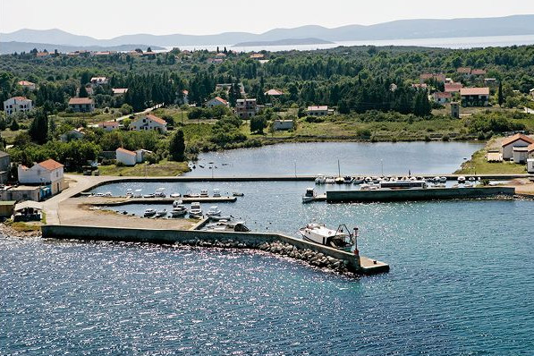
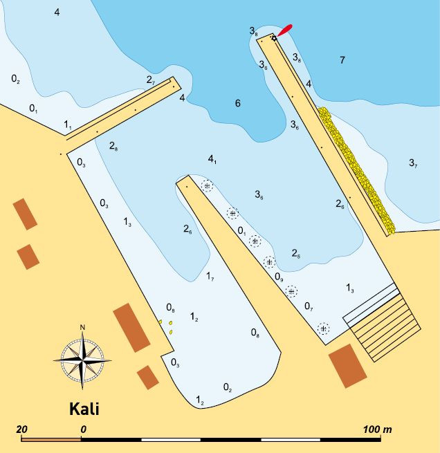
44°04’N, 15°12.4’E – lighthouse at breakwater head (E Kali Harbour)Kali is today a most famous fishing vil-lage, not only in Croatia, because there are many people from Kali with excellent fish-ing skills sailing in far away oceans. Two Kali harbours bear witness of this fact, of-ten crowded with big fishing boats. Kali is first time mentioned in 1343. One to Kali’s landmarks is definitely Church of St. Lawrence built in Baroque style in the 17th century. Small Chapel of St. Pelegrinus is older, dating from the 14 th century.Anchorage in the Approach
The coast in approach to Kali is shallow and you can anchor near the harbour. The bot-tom is sandy, and you can anchor at depths of 5–10 m. The anchorage is shielded only from winds from the fourth quadrant. Try not to block heavy ferry traffic here.
Entrance
Enter Kali Harbour between breakwater with a red lighthouse and the head of a smaller breakwater vertical to a lighthouse. Entrance is about 30 m wide, and about 4 m deep.
Moorings
At the breakwater head (with the lighthouse) the depth is 6 m. On the inner side of the breakwater head the depth is 5 m, and at about middle it drops to 3 m, and at the in-tersection between the breakwater and the coast the depth is 1.5 m. At the end of the breakwater a boat winch begins, and at the other end of the winch there is another, inner breakwater. On the winch side the sea is shallow alongside the breakwater, almost all the way up to the head. At the head the depth is 4 m. The inner breakwater protects the most shielded part of the harbour from N winds, making together with the mainland a basin with local boats. Depths are from 2 m at the entrance to this part of harbour to 0.5 m alongside the coastline. At the breakwater that stretches vertically from the coast to the light-house depths are: 4.5 m at the head, 4 m on the inner side, and then it drops to less than 1 m at the intersection between the breakwa-ter and the coast. All harbour berths are most frequently occupied by trawlers, purse seiners and local boats. It is similar in the other Kali Harbour. It is made of the breakwater which stretches from the coast N into the sea. At its head the depth is 3 m, and on the inner side it drops to 1 m alongside the coastline. Entrance is wide (around the breakwater), and the depth is deeper than 5 m. There is a shipyard ashore.
Kali Harbour (with the lighthouse) is not completely protected from N winds.Nearby Anchorages
Preko – a cove between the island of Galovac and N Preko Harbor. Two miles in NW course, rounding the island of Galovac on E side (the channel between Galovac and Ugljan is shallower than 1 m). The cove is well protected from all winds, and the anchorage is at depths of 5–10 m. The bottom is muddy.Ošljak – 0.5 nm away from Kali Harbor, but watch out for heavy ferry traffic passing by its W side. During daylight it is common to anchor in the refuge of the is-land from the sea breeze, and at night it is better to secure in Ošljak Harbor, which is situated in the part of island protected from the bora. The breakwater protects the harbor from the W winds, and the depth at its head is 3 m. On the inner side it is about 2.5 m, up to the middle where it begins to drop. The ferry does not secure on the inner side of the breakwater, but on the quay opposite the breakwater head. The harbor is protected from all winds.
Ortić Point – if the forecast is calm weather without wind, you can anchor in one of two coves around Ortić Point. The bottom is sandy, and the anchorage is at depths of 5– 10 m. The anchorage is protected only from W winds. In SE cove there is a stone water-front of a big former quarry. The depth in S part of the waterfront is about 1.5 m. At the other end it is shallower.

KUKLJICA
44°02.1’N, 15°15.5’E – green lighthouse on breakwater and at entrance to Kukljica Cove
Anchorage in the Approach
The h arbour in Kukljica Cove is rather spacious, but provides many securing oppor-tunities, and it is not usual to anchor inside or in front of it. On the peninsula enclosing Kukljica Cove in E there is a big camp (in pine forest) and there are many bathers on the entire peninsula. If the sea breeze is blowing, you can anchor in leeward of this peninsula. The bottom is unreliable, and the anchorage is at depths of 5–10 m. The a n-chorage is protected from the sea breeze, but not from other winds.
Entrance
Entrance between two breakwaters is 70-odd m wide. Depth between is 8 and 10 m. After passing between breakwaters, head for free spot in E of Kukljica Cove. W side is occu-pied by fishing boats.
Moorings
Just behind entrance the breakwater depth is 6 m. The depth along the inner side of the breakwater drops to 3 m, and towards the end it is 2 m. One hundred-odd m towards the end of the cove there is another wide concrete quay where usually bigger boats secure. Behind this wide concrete quay, in the cove aquatorium, there are five long pontoons for yachtsmen. The first three in E of the cove have not been provided with electricity and water cabinets yet. On these three pontoons there are spaces for 30-odd vessels on either side. The sea depth at the head of pontoons is 5 m at the first, and 4 m at the other two. Coastbounds the depth gradually drops. All berths are provided with moorings. At the intersections between the pontoons and the coast the depth is about 1 m. Inshore is shallow, and the third pontoon (furthest in the cove) consists of two parts. The old, stone part extending to the new, concrete part. It is shallower alongside the stone part and there are many local boats tied up. At the inter-section between the old pontoon and the coast there is a wide winch. The coast part that separates these first three pontoons from the other two which are at the end of the cove, is convenient for securing vessels below 0.5 m drought. The remaining two pontoons stretching side by side into the sea towards W end of the cove are provided with electricity and water points. All berths are provided with moorings, and depths are between 2 m at the beginning of the pontoon to 4 m at the pontoon heads. On W side of the cove there are many quays with local fishing boats tied up.
Weather Conditions
Kukljica has always been well protected from winds from the first and second quadrants. After pontoons for yachtsmen were built, the impact of S winds was reduced, because the pontoons stop bigger waves from rising inside the cove.
Nearby Anchorages
Gnojišća Cove – less than one mile along-side the coastline, to NW after rounding the point which protects Kukljica from the bora and winds from the first quadrant. In the cove the anchorage is at depths of 5–10 m. The cove is not a good refuge from the bora and the tramontana. The bottom is sandy. In the cove there are two concrete quays protected by breakwaters, from piled rocks.

LAMJANA
44°19.8’N, 15°13.5’E – southernmost point (Zaglavica Point) of peninsula separating Lamjana Mala and Lamjana Velika
Anchorage in the Approach
Entrance to Lamjana Mala is 0.5 nm wide, and you can anchor alongside the coastline at depths of 10 to 5 m, which leaves many anchoring possibilities to yachstmen. From entrance to the end of the cove it is almost 1.5 nm. The best anchorage is on the E coast of the cove, just be-hind the entrance, where boats are protected from all winds. Be careful in this part of the cove if the weather fore-cast is squall.
Entrance
Entrance to La-mjana Mala is wide and midways 30-odd m deep.
Moorings
There are several quays in Lamjana Mala used to tie up fishing boats (trawlers). In Lamjana Velika there is the harbour infrastructure to accommodate bigger merchant ships.
The cove is well protected from all winds, but as it is spacious, choose E or W of the cove relative to the wind direction and weather forecast. Facilities Alongside Lamjana Mala coastline there are a lot of private houses rented by tou-rists in the summer. There is no public provisioning.Connections
Both coves are interconnected by road, and in the same way also to other island settle-ments. Ferry connection with the mainland via Preko Harbour (on Ugljan) or Tkon Harbour on Pašman.
Nearby Anchorages
Sabušica Cove – it is situated 1 nm south of entrance to Lamjana Mala Cove. In approach, after rounding Karantun Point, watch out for the submarine reef in vicinity of this point. Bottom is sandy, and the anchorage is at depths of 5–10 m. The anchorage is not protected from W winds.

TURANJ
43°57.9’N, 15°24.8’E – lighthouse at main marina breakwater
Entrance
When entering the harbour, keep close to the breakwater head (with the lighthouse) because the N part of the harbour is shallow.
Moorings
At the breakwater head (by the lighthouse) the depth is 4 m, and turn-ing inside, halfway of the inner side of the breakwater the depth is 3 m, and at the corner of the breakwater it drops to 2.5 m. If there is no S wind, you can also se-cure to the outer breakwater. Closer to the breakwater head (lighthouse) the depth reaches 4 m, and at the S end of outer breakwater it gradually drops to 1.5 m. From this section, vertically to the mainland, it is shal-low and full of big rocks. Do not try to secure at all. Opposite the main breakwater there is a smaller breakwater which protects from N winds. At its head the depth is 1.5 m. This well protected harbour has another, inside pontoon on concrete piers (the pontoon and the N breakwater are used for water-polo). The depth rises from 0.5 m alongside the mainland to 1.5 m at its end. North and south off the fishing harbour there are many havens with local boats. During ebb tide many boats on bare bottom. Recommendation: Do not enter.
Weather Conditions
The harbour is rather exposed to SE winds, which regardless of the breakwater protection, raise big waves and swell, and sometimes also splash over. In summer squalls (SW winds) it is dangerous to stay in the harbour.
Nearby Anchorages
Taline Cove on Pašman is about 2.5 nm W off Turanj. Depths are between 3 and 8 m. It is a good refuge in S and W winds. When entering, do not use the course between the islands of Garbenjak and Pašman as the depth is below 1 m.
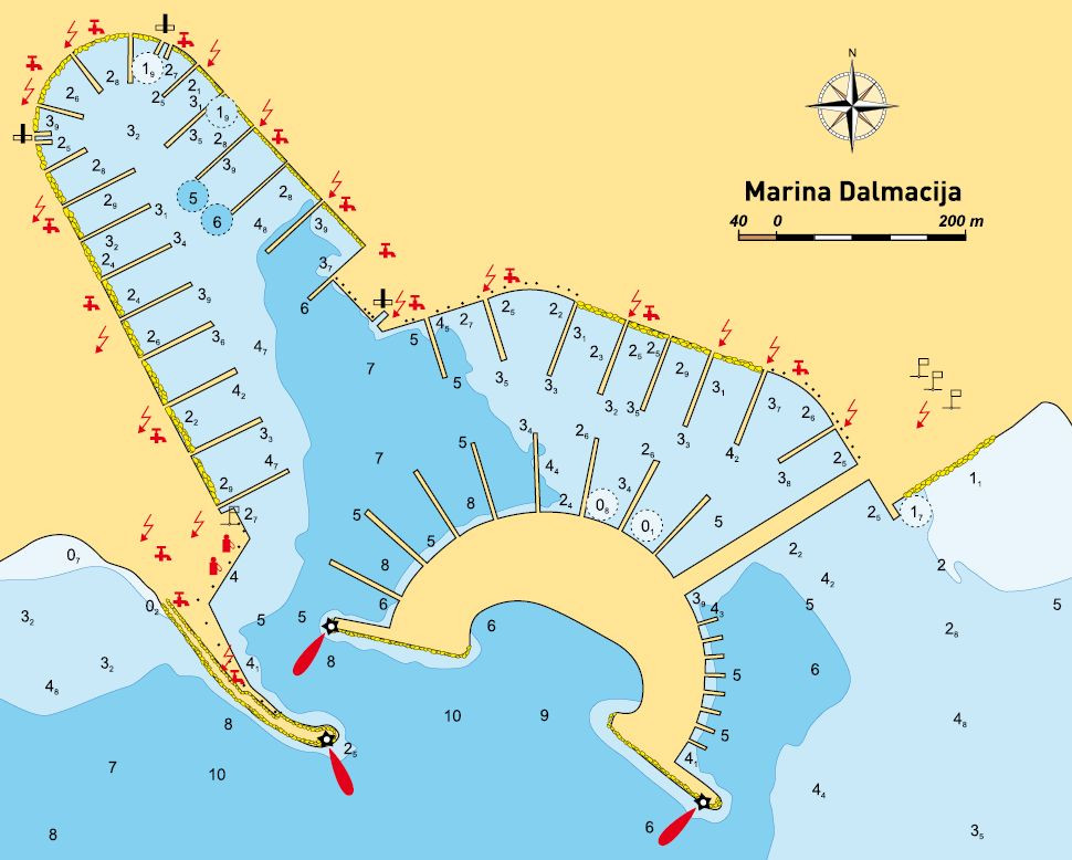
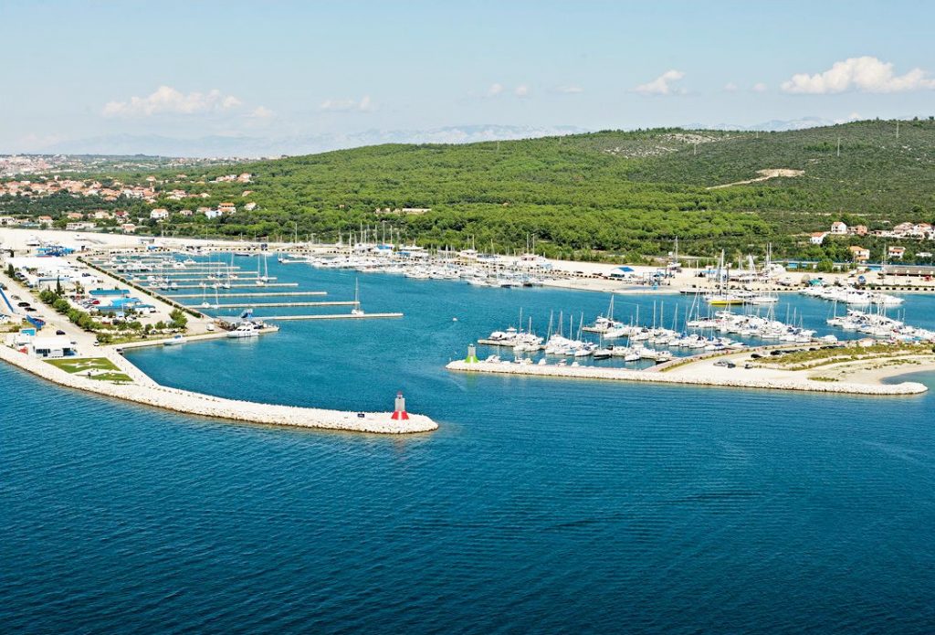
SUKOŠAN
44°03’N, 15°18.2’E – lighthouse on Sveti Ivan Point (at the head of marina breakwater)
General
Marina Dalmacija was foreseen as the biggest marina in the Mediterranean. Due to the war it was not finished within the planned time framework, but the construction works continue every year, so that it can provide yachtsmen with better services. Marina Dalmacija with more than 1,000 berths is one of the biggest charter centres in the Adriatic. Although it is situated in close vicinity of Sukošan and Bibinj, the marina functions independently, providing yachtsmen with services within the marina. It does not include ca-tering services, which are mostly alongside the main road (Adriatic highway) and in the mentioned settlements.
Approach
You can approach the marina in line with the coast from NW, SE or W, piloting be-tween the islands of Pašman and Ugljan through the sea by Ždrelac. The only hazard, regardless of the side you come from, is the shoal between the lighthouse on Podvara Point and the mainland. The shoal stretches alongside the coastline to Kažela Point.
Anchorage in the Approach
You can anchor at the SE end of the cove. The anchorage is at depths between 2 and 5 m. The entire S and SE coast alongside the settlement of Sukošan is shallow, so be careful when choosing the anchoring spot. The cove is protected from all winds. The northeast wind is strong, but does not raise waves.
Entrance
Entrance to the marina is between the red lighthouse at the breakwater head and the green lighthouse at the N head of the inner breakwater. Entrance width is 50-odd m, and the depth in the middle from 10 m at entrance, to 5 m among the first pontoons.
Moorings
Berths for biggest boats and those with biggest draught are situated on the artificial peninsula, just behind the green lighthouse at entrance. The depth on the peninsula pontoons is from 8 m on the northern-most the pontoons to 5 m on pontoons in vicinity of the intersection (seawall) with the mainland. On the pontoons situated in the extension of Sveti Ivan Point (red lighthouse), just behind the fuel station, the depth is somewhat bigger on the first one (about 4 m), and the others provide berths for boats below 3 m of draught. There is same depth in the entire cove which stretches from the artificial island to NW. In the section of the marina opposite the artificial island, the sea depth alongside the jetties is 3 m, and by the coast 2.5 m. You can use different services inside ma-rina. The reception desk is in the marina section with the fuel station, at the level of the seventh jetty. All sea berths are provided with electricity and water. Almost one third of the mainland space is reserved for dry berths. The marina has six points with toilets and showers. There are four 30–65 t travel hoists. Car parks are alongside entire marina. There are several coffee-bars and two restaurants. The laundry is situated between the fuel station and the reception desk. The marina has well organized dan-gerous waste disposal. There are several repair services, sail-makers, yacht chandlers…
Connections
The marina is situated in close vicinity of the Adriatic highway. It is 5 km away from Zadar, and 7 km from Zadar Airport.
Nearby Anchorages
Bibinje is a place 1.4 nm N of Sukošan with a haven and a quay with 2.4 m depth at the head, and everywhere else it is considerably shallower. You can anchor in front of the harbour, and only smaller boats inside the breakwater. Polača Cove , 2 nm SW on the island of Pašman. The bottom is sandy, and the anchorage is at the depth of 5–10 m. It is protected from all winds, except the bora.
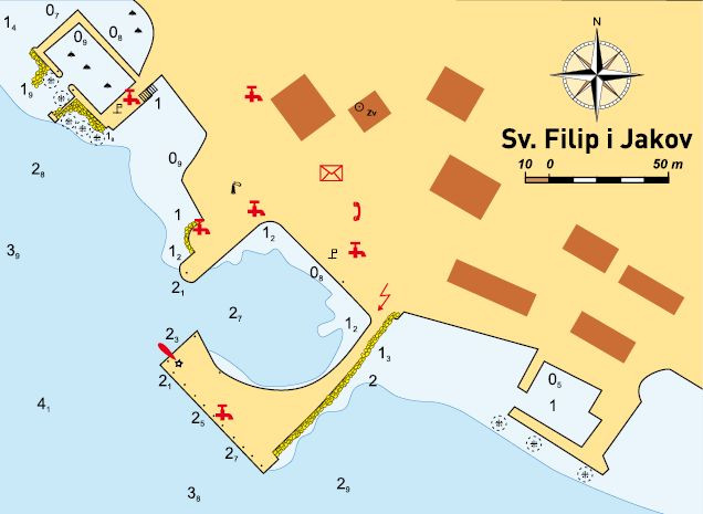
SVETI FILIP I JAKOV
43°57.1’N, 15°25.5’E – Kočerka Shoal
Points of Interest
Sveti Filip i Jakov grew out of a cluster of old villas and aristocratic gardens, demonstrating how in the past people knew how to appreci-ate natural advantages of this region.
Approach
A small town is towered by two belfries, the one closer to the coast is in close vicin-ity of the fishing harbour. Seaward, the fishing harbour is unusually rich in trees as there is a town park in its close vicinity. N of the town harbour there are several arms of an interesting (old) haven stretching into the sea, but only small boats can enter there. At the main breakwater head, which is unusually wide, there is turned off lighthouse. It is red and neglected. Vessels with draught below 1 m can secure in the town centre, S of the intersection between the main breakwater and the mainland. The harbour is protected from all N and NE winds, but does not provide good protection from other winds.
Anchorage in the Approach
In the case of the bora you can also anchor north and south off the fishing harbour at depths of 5–10 m. In the case of the south wind, it would be better to seek the safer refuge (further away).
Entrance
Try to avoid entrance to the fishing harbour. If the weather conditions allow it, it would be best to secure to the outer breakwater and the breakwater head. But it is not recommendable to stay there in the south wind or the tramontana. When securing, watch out for the sea currents. For boats with smaller draught (below 1 m), there is available approach to the quay south of the breakwater.
Moorings
On the outer side of the main breakwater (in line with the coast) depths are from 2.5 m in the middle to 3 m at the breakwater ends. The b reakwater head is also good for securing with depths of about 3 m, but watch out for the rocks around the breakwater head at the point where the breakwater and the mainland enclose entrance to the harbour basin. Berths S off the intersection between the breakwater and the mainland are for boats with smaller draught. Depths are below 1.5 m.
Weather Conditions
The harbor is rather exposed to S winds and waves. Squalls from the fourth quad-rant are also dangerous.
Connections
Sveti Filip i Jakov is in close vicinity of an Adri-atic highway, 20-odd km away from Zadar.
Nearby Anchorages
S of an island of Babac there are good anchorages during daylight. Between the islets of Dužac , Veliki Dužac and Mali Dužac , and the place called Kraj on Pašman, good anchorage at depths of 4.5–5 m.

BIOGRAD
43°56.2’N, 15°26.2’E – lighthouse at the head of town harbour
Points of Interest
The county museum on the waterfront contains some archaeological exhibits from prehistory to Early Croatian Age. Items found on a Venetian ship, which sank at the end of the 16 th century nearby the islet of Gnalić, are especially appealing.
Anchorage in the Approach
N and S of entrance to Biograd Harbour, the coast and its appertaining archipelago are com-pletely enclosed by breakwaters which protect the berths in the marinas. There is a good an-chorage in approach to Bošana Cove , with the northernmost breakwater of Marina Kornati. The anchorage is at depths of 4–7 m. The an-chorage is not protected from winds from the fourth quadrant. Between the lighthouse at the jetty head of Biograd Harbour and entrance to Marina Kornati it is prohibited to anchor.
Entrance
There are basically three entrances. The first one takes you to the old harbour of the town of Biograd, which is situated by the lighthouse E3185 at the breakwater head. Entrance is between the lighthouse and opposite the head of the L-shaped breakwater that protects the har-bour in the S. It is deeper by the lighthouse (about 6 m), while at the head of the L-shaped breakwater the depth is 2 m. The second entrance is entrance to Marina Kornati and Marina Šangulin complex. It is situated NE (alongside the coastline) of the old harbour, and marked by two lighthouses. At the head of the E breakwater there is a red lighthouse E3185.2, at the head of the W breakwater there is a green lighthouse E3185.4. The depth midway of entrance to the marina is 6 m. The third entrance is made of the breakwater which is S of the old town harbour, and the shore of the narrowest town centre. The breakwater constitutes an aquatorium in close vicinity of the hotel. At entrance to the oldest marina of the town of Biograd the depth is below 2.5 m.
Moorings
In the old town harbour you can moor along-side the inner side of the breakwater with the lighthouse, alongside the coastline, and to the L-shaped breakwater which protects the har-bour from S waves. At the lighthouse the depth is 6 m, but drops to 3 m at the intersection be-tween the breakwater and the coast. Inshore is 2 m, and it becomes shallower at the intersection between the breakwater and the coast. Along the inner side of the L-shaped breakwater the depth grows, at the joint is 1.5 m, and at the head, i.e. at the end of the breakwater, it is 2 m. In Marina Kornati there are 500 sea berths. The deepest berth depth is 5 m, and the deep-est berths are on jetties at the N end of marina. Boats below 30 m of length can tie up there. On land there is space for 200 vessels (dry berth). All berths are provided with water and electricity.
CROATIA CHARTER FLEET
Search the entire Croatia Sailing EU fleet to find your ideal yachting vacation including the best sailboats and motorboats.
BOOK BOAT FOR CROATIAN HOLIDAYS TODAY!
TAGS: BOAT CHARTER CROATIA, NAUTICAL PILOT FOR ADRIATIC, NAUTICAL PILOT FOR KROATIEN